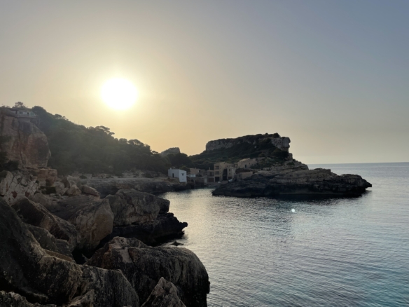

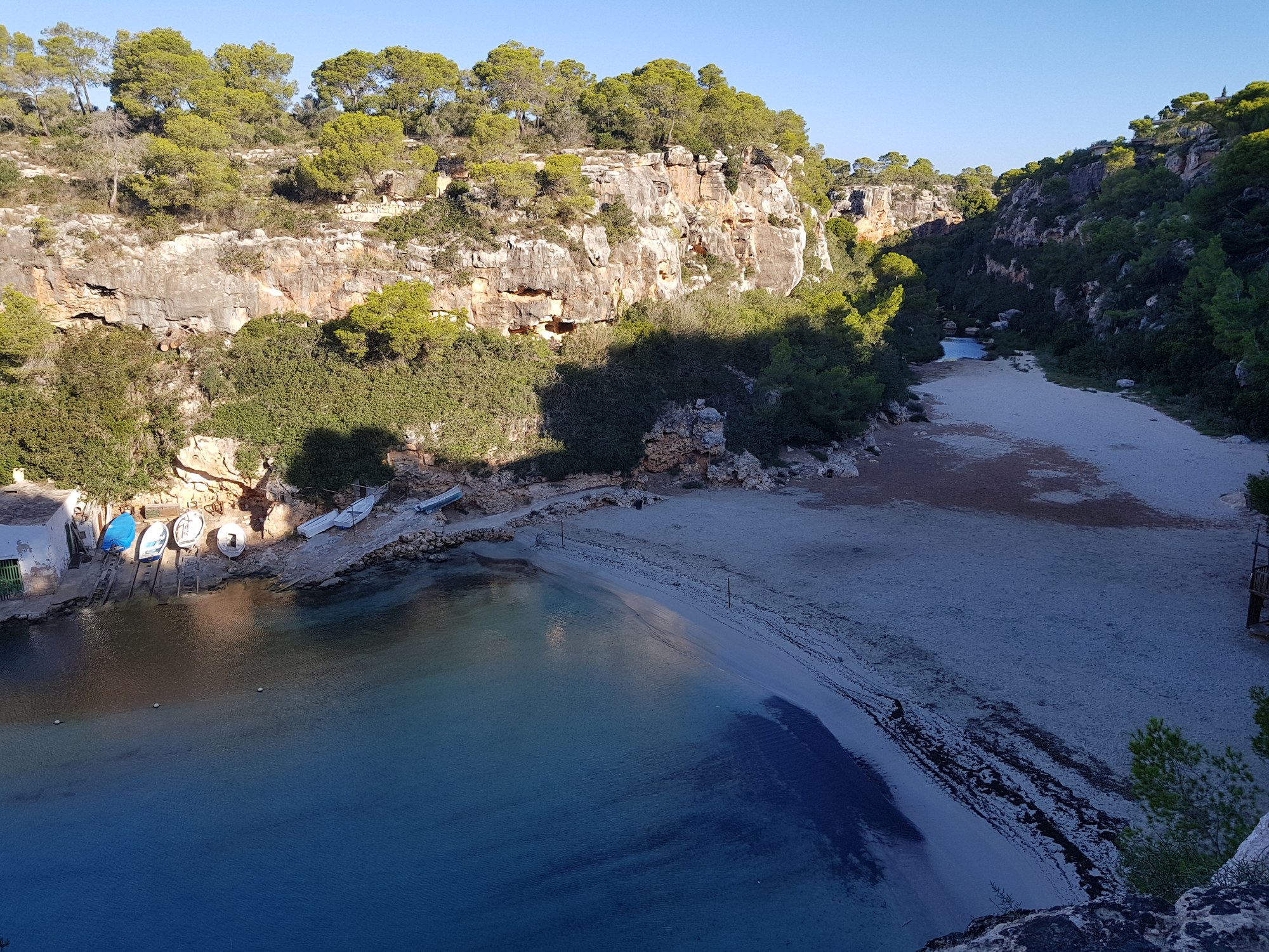
The short version: Cala Pi is a narrow cove on the south coast of Mallorca, in the municipality of Llucmajor, wedged between limestone cliffs at the mouth of a torrent. At the far end there is a small beach of fine sand; along one side, the fishermen’s boat huts; on the headland, a round watchtower completed in 1663. You reach the sand down a long staircase from the residential area above, and you park up there. The cove is small and fills up in summer, which is why the people who know it go on weekdays or out of season. This guide explains how the cove works and what surrounds it.
What Cala Pi is
Cala Pi takes its name from the torrent that flows into it, according to the Llucmajor tourism office (Visit Llucmajor). From the air it looks like a long, thin bite out of the coast: a channel of turquoise water running inland between two walls of rock, ending in a short beach where the torrent bed meets the sea.
The Balearic government’s survey of sites of geological interest explains the shape: the torrent cut the cove along a system of large faults in the rock. The cliffs belong to the Marina de Llucmajor, a limestone platform built from tropical coral reefs of the Upper Miocene, roughly 12 to 5.5 million years ago, and the fossil corals are still visible in the walls around the beach (Govern de les Illes Balears, Sites of geological interest).
For an American, the closest picture is a small canyon mouth on a rocky coast rather than an open beach: you look down into Cala Pi from above before you ever reach the water, and the cliffs frame everything you see from the sand.
Getting down: the staircase and parking at the top
There is no road to the sand. The government’s geological survey describes the access as a staircase signposted Platja (beach) that starts in the Cala Pi residential area and takes about five minutes to walk down. The tourism office calls it a long staircase.
Cars stay at the top: in what we see, people park in the residential streets above the cove and walk to the stairs. Everything you take to the beach, from water to shade, goes down the steps with you, and there is no other way to the sand for strollers or anyone with limited mobility.
The beach, the boat huts and the water
The beach itself is fine sand with a gentle slope into the water, and the tourism office describes how the strong turquoise near the shore blends into the clear green over the sea bed. On the western side, above the boat ramps, stand the boat huts where the fishermen’s boats are hauled out of the water, one of the images of the cove; and a path above them leads on to Cala Beltran, a small undeveloped sandy beach next door, according to the tourism office.
These are the services listed by the tourism office for Cala Pi:
- Cleaning and recycling bins on the beach.
- No sunbed or umbrella rental: shade is yours to bring.
- The Ecoplayas flag, an award for beaches with an environmental quality policy.
The town hall also includes Cala Pi, together with s’Arenal, in its surveillance and lifeguard service for the bathing season, according to its public tender for the 2026 and 2027 seasons (Ajuntament de Llucmajor, EU tender notice).
The tourism office’s walking guide adds that, because the cove is so narrow, it can lose part of its sand when the sea is rough, so after a storm the beach may look different from the photographs.
The Torre de Cala Pi: a watchtower from 1663
On the cliff top beside the mouth of the cove, close to the sea, stands the Torre de Cala Pi. The long coast of Llucmajor needed a chain of defense and lookout towers: according to the municipal tourism office, they were built mainly in the 16th century, when the island lived under the threat of raids from the sea, and the watchmen signaled with fire at night and with smoke by day when they sighted enemy ships (Visit Llucmajor, defense towers).
Cala Pi’s tower came last: because the cove is narrow and enclosed by cliffs, landing there was difficult. According to the tourism office, the master builder Joan Pons completed it in 1663; it stands 10.2 meters high on a base 9.95 meters across, about 19.5 meters above the sea, and its round sandstone door was reached by a rope ladder. Around 1970 it was restored by its owners. The tourism office also recalls that this stretch of coast was one of the most active on Mallorca for smuggling, with tobacco as the main cargo.
Weekdays and the quiet months
Cala Pi is small, and in summer it fills up, as the August day in the video above shows. In what we see, the people who live in the south of the island and know the cove go on weekdays, or in the months either side of the summer, when the beach has room.
The geological survey notes that Cala Pi can be visited at any time of year, with a hat, water and comfortable shoes, and that in summer you can enjoy a swim.
Along the cliffs: Cala Beltran, Cap Blanc and the lighthouse
Cala Pi is also the starting point of one of the coastal walks the Llucmajor tourism office describes: Cala Pi to Cap Blanc and back, about 10.9 km (6.8 miles) and four hours, rated easy (Visit Llucmajor, Cala Pi to Cap Blanc). The route crosses the beach, passes the fishermen’s huts and climbs the cliff. Along the way:
- Cala Beltran, a small cove where, the tourism office warns, swimming is not advisable in rough seas because of the waves between its narrow walls.
- The Capocorb headland, with views along the coast and on clear days the island of Cabrera on the horizon.
- The Torre de Cap Blanc, built in 1579 by Antoni Genovard, a stonemason from Sineu.
- The Cap Blanc lighthouse, which the tourism office dates to 1863, inside a restricted former military area and seen from outside.
Part of the route runs over bare rock without a marked path, close to high cliff edges. The government’s geological survey lists other sites of interest around the cove, among them the Roman quarry of Cala Pi.
Cala Pi and Vallgornera: what is above the cove
The residential area of Cala Pi spreads over the plateau around the head of the cove, and next to it, to the east, lies Vallgornera. In what we see, both are made up mainly of detached houses with gardens on the flat limestone platform. Llucmajor, the town inland with its market, secondary school and health center, is about 30 minutes away by road; our guide to the Pla, inland Mallorca describes it.
Beneath this stretch of coast lies a cave nobody can visit. The Cova des Pas de Vallgornera has more than 74 km of galleries, one of the largest caves in Spain, according to the Balearic government, and was discovered by chance in 1968, when a well was being dug. It is a protected site of the Natura 2000 network, closed to all visits except scientific expeditions, and entry without the appropriate permits is prohibited (Govern de les Illes Balears, Sites of geological interest). Among its fossils, the government’s survey lists remains of Myotragus, an extinct goat-like mammal native to the Balearic Islands.
Getting there
Driving times to the Cala Pi residential area, from OpenStreetMap routing in free-flowing traffic:
- From Palma (city center): about 41 minutes, around 41 km (25 miles).
- From Palma airport: about 38 minutes.
- From Llucmajor: about 30 minutes.
- From s’Estanyol, the next harbor east: about 21 minutes.
- From Campos: about 29 minutes; from Ses Salines, about 34; from Colònia de Sant Jordi, about 36; from Santanyí, about 42.
Seven minutes inland by road is Capocorb Vell, a prehistoric Talayotic settlement with three circular and two square towers at its core, declared a historic-artistic monument by government decree on 3 June 1931, according to the tourism office (Visit Llucmajor, Capocorb Vell). To compare the south coast with the rest of the island, our guide to where to live in Mallorca covers every area.
What you need to know
How do you get down to Cala Pi beach?
By a staircase signposted Platja from the Cala Pi residential area, about five minutes down. There is no road to the sand, so cars stay at the top.
Where do you park for Cala Pi?
Up in the residential area above the cove, then walk to the stairs. The cove is small and fills up in summer, so people who know it go on weekdays or out of season.
Are there sunbeds or a lifeguard at Cala Pi?
There is no sunbed or umbrella rental. The town hall arranges a lifeguard and surveillance service for Cala Pi during the bathing season.
How old is the Cala Pi tower?
The Torre de Cala Pi was completed in 1663 by the master builder Joan Pons, the last defense tower built on the Llucmajor coast, according to the municipal tourism office.
Can you visit the Cova des Pas de Vallgornera?
No. It is a protected Natura 2000 cave, closed to all visits except scientific expeditions, according to the Balearic government.
Where we work
We work across Mallorca from our base in the south-east, where you can browse homes in Santanyí, homes in Ses Salines and homes in Campos. Whatever area you are considering, the Llucmajor coast included, contact Villas y Fincas Mallorca and we will answer in English.
Updated October 2026. Driving times come from OpenStreetMap routing and vary with traffic and season; facts about the beach, its services, the towers, the coastal walk and Capocorb Vell come from Visit Llucmajor, the municipal tourism office; those about the geology of the cove and the Cova des Pas de Vallgornera from the Govern de les Illes Balears; and the lifeguard service from the Ajuntament de Llucmajor’s tender notice, all consulted in October 2026. The descriptions reflect what we see and are for general information only.